Deciding which path to take when hiking on Drummond Island feels like a choose-your-own-adventure story. Our hiking options are limitless, and the path you choose will always be the right one. For those looking for tree-canopied lanes or a robust hike through state lands, we have it. Drummond Island has four established hiking trails. Free detailed maps are available at the Visitor’s Center.
Drummond Island Heritage Trail
The Heritage Trail is a 3.0-mile nature trail for hiking and snowshoeing located at the Drummond Island Township Park. It offers a unique experience for birding, hiking, or geocaching in the warmer months, and for snowshoeing in winter. There is a great variety for a trail of this size. The Lower Level leads you through beautiful woodlands as it travels to the rocky beaches that define the Drummond Island shoreline. Trail use is free. The varied forest terrain and location on the shore of Potagannissing Bay bring together many different habitats in a small area. Flora lovers will enjoy the woodland flowers that mark the inner trail system and are seen in great numbers in the small natural forest openings. Traveling through many habitats, the trail is rich in woodland wildlife year-round. Look for whitetail deer and signs of other animals on your hike. Watch for forest birds along the trail, and waterfowl and loons on the bay.
The trailhead is located on the park entrance road, 0.3 miles from M134. Parking is available at the trailhead. Bathroom facilities are available at the Township Park in the summer months. The trail is marked with wooden directional signs and “You Are Here” location maps. The majority of the trail can be hiked or snowshoed easily by the novice. Trail maps are available at the trailhead and at the Drummond Island Tourism Association (DITA) office.
Clyde and Martha Williams Preserve Trail
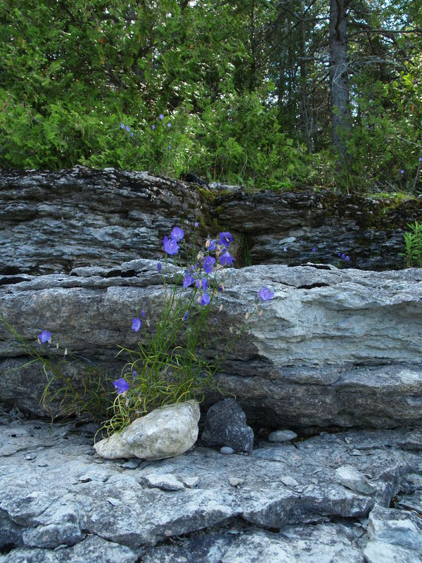
The Williams Preserve is mostly forested with either upland mixed hardwood/conifer stands (including white pine and hemlock components), northern hardwood stands dominated by beech and maple (with minor components of ash, ironwood, basswood, and balsam fir), and lowland areas dominated by cedar, balsam fir, and paper birch. Fallow agricultural fields now vegetated with bracken fern, blackberry, and various tree seedlings and saplings are present in small areas. Soils in some areas are flat and sandy, while in others they are very rocky, with some large boulders. Fissured bedrock is visible at the surface in some spots. Ancient post-glacial lake shorelines are evident on the Preserve. An old stone wall built by early Island settlers is located in the eastern part of the Preserve. The trail, owned by the Little Traverse Conservancy, opened in late summer 2008. Its trailhead is located at the east corner of the Maxton and Tourist Road intersection. A parking area is provided, and its close proximity to Drummond’s main lodging complexes should make this trail popular.
Forslund Dix Point Preserve
Owned and managed by the Little Traverse Conservancy, the 60-acre property has 1800 lineal feet of
shoreline on the St. Mary’s River. There is an approximately 1/4 mile trail to access the shoreline on the
point, and then it loops around back to the trailhead. Benches are along the shoreline for freighter and
bird watching, with great views toward the west, north, and east. It is a good place to hike or snowshoe and
launch a kayak. Parking (limited parking, no trailers) is available at the end of S. Dix Point Road.
Big Shoal Bay Park
The newest trail on the island starts at the Big Shoal Beach parking area, where you’ll find easy access to the forest and a vault toilet. This peaceful loop winds through a lush, meditative woodland—ideal for a short walk or snowshoe outing. Watch for birds and hidden forest treasures along the way.
Nature Trails at Drummond Island Resort
The Drummond Island Resort offers two hiking loops within the resort property. The shorter, 1-mile loop is an interpretive trail ideal for younger kids exploring with an adult. Off this trail, pick up a 2.5-mile loop that borders the Resort’s golf course. Easy access to the trails is located behind the main lodge area. In colder months, the marked hiking trails are ideal for snowshoeing
State Land Trails
Additionally, the Island features 117 miles of state land off-road vehicle trails. They are described as potentially hikeable, although these trails are rated demanding for off-road vehicles and are extremely rugged in some areas. The snowmobile trail system grooms 68 miles, 45 of which are state-owned. The percentage of the snowmobile trail that is accessible to the public on foot is not known due to this trail system being contiguous with and often only accessible through private property.